Thursday, December 30, 2010

mrnyc's annotated walk down the Bowery circa 2008

"An annotated walk down the bowery in lower manhattan (long) - part 1"
is from the Urban Ohio forum.  Stumbled upon this last night - seems like a bit of a walk back in time....

Lots of information and some pictures, including some from when the "Outsiders" show was up on the corner of Bowery and Houston.  See this earlier post for details.  That space is now a fancy restaurant. 

pictures by mrnyc


(Photo: Ian Cox/Lazarides Gallery)

Skidmore House and 2 Cooper Sq

I recently realized I've gotten a bit off track lately....diving in to maps and history is just so tempting but now that I'm looking at less than a week to put together a collage I've realized I need to focus more on the present and recent past.  I think its also easy for the mind to stray when you are not physically in the city....once you are back and pounding the pavement commences the urgency to address today's issues returns.

So let us return to current issues.

37 East 4th Street was vacant for as long as I can remember.   We always thought it'd be a super place to live.  It had this great little curved edition building on the back that was so cute.

This NY Times article from 2004 explains what happened.  It also states "In the longer term, the Atlantic Development Group has leased the Skidmore House and an adjacent property at the corner of the Bowery from the Goldman estate. It plans to restore the landmark as part of a larger project."

Fast forward to now and both the Samuel Tredwell Skidmore House and its much larger neighbor 2 Cooper Square are ready for occupancy.

I always thought the architects of 2 Cooper must have been inspired by some of the Skidmore House stylings, especially the back garden "tea house" (as its called in this Curbed article about the house).


Picture of the Skidmore House from 2004 via the NY Times/Dan Hogan Charles 
Also, here is a 1987 article from the NY Times explaining what happened to the buildings in the middle.


Here are some pictures I took from early 2008 of the Skidmore House looking from the Bowery.


A November 2010 NY Times article gives more info about the renovations, and a picture of the building next to 2 Cooper Square. Chester Higgins Jr./NYTimes


From the Wired New York forum - posted by Derek2k3


I found this too and can't resist posting it: from New York Magazine April 30, 1973 via Google Books


And lastly.....this PDF from NYC.gov confirms that those big round things they buried in the lots between 29 and 37 East 4th Street (pictured above) were for the 3rd water tunnel.

Wednesday, December 29, 2010

Eldridge Street time lapse

A diversion from The Bowery but related in some respects.......I just looked up the Delancey Farm and found this really excellent time lapse animation (I remember seeing it awhile ago but forgot about it, though I think its gotten more extensive since then).

Here is the sped up version of "The Block" by Zach van Schouwen. Click here for the web site version where you can vary the speed.

Its fascinating that in the late 70's almost all of the tenements disappear, since if Robert Moses had his way they would have anyway in the 50's.   I bet the Rivington School artists used this space frequently, though I seem to remember hearing that there was some sort of zen garden type art piece there in the 80's and its driving me crazy that I can't find a link.....(ok, found it.  It was on the other side of the street from this animation.  Adam Purple's Garden of Eden must have been beautiful in an otherwise burnt out LES.) 


Adam Purple's Garden of Eden

Monday, December 27, 2010

Birdseye views - Google earth vs. 1879 Library of Congress map

While debating the other day how panoramic maps were made, and the idea was brought up that cameras were used in balloons, and drawings made from the pictures.  A Wikipedia article on pictorial maps has this to say "Edwin Whitefield for instance, one of the more prolific 19th century American pictorial map artists, would require about 200 subscribers before he put pen to paper. Once he secured the profitability of the venture, Whitefield would be seen all over town furiously sketching every building. Then, choosing an imaginary aerial vantage point, he would integrate all his sketches into a complete and detailed drawing of the city. Then after that, say the chroniclers of the time, Whitefield would once again be seen furiously darting all over town to collect from all his sponsors. Says Jean-Louis Rheault, a contemporary pictorial map illustrator: 'Pictorial maps - with their emphasis on what's important and eye-catching - make it easier to figure out what's where.'.[2]"

Full map at the Library of Congress can be found here. 

Forgotten NY Bowery page + 190 Bowery

Learn some more about the history of some of the buildings still standing on the Bowery here, at the Forgotten NY website.

While scrolling though its contents I was reminded of the mystery that is (was) 190 Bowery.

I had the pleasure of getting a tour of 190 Bowery along with a group of Cooper Union students  (photographer Jay Maisel's studio/home) in the early 2000's. We saw his studio/office spaces, which were still fairly intact in terms of what the place was like when it was a bank (the vault in the basement, large conference room with big wooden table, the wooden stairs up to the offices, the mosaic bank lobby floor). A large portion of the second floor was a gallery space for his work, and some shooting studios. I remember in the early 90's we used to walk from the LES to the fleamarket at Grand + Broadway on weekends, and speculate what was going on in that building. It was amazing to go inside, but sad in some ways because all the mystery has been removed from it for me.

For better or worse, I will now demystify it for you (not that its hard at all to find info about it these days).  Here is a NYMag article and slideshow from 2008.

Photo: Leigh Davis via NYMag.com

The last surviving Federal-style row house on Bowery

This entry about 206 Bowery on the Place Matters website tells us all about this building and some of the surrounding buildings. "This is not only the last Federal Row House style building left in this storied area, it is one of the few remaining in all of downtown Manhattan."

Photo by Sally Young via Place Matters

Art about the Bowery + "The Last Days of Loserville"

I had planned on talking about East 2nd Street for a bit, and digging up more pictures of the Liz Christy garden, but yesterday's snowstorm is keeping me from getting back to the city so I can access my negatives.  In the meantime I've been digging thought the Village Voice, which, not surprisingly, holds a different blend of information covering some of the same events in articles I posted from the Times.


Mid 2000's......there is an article titled "The Last Days of Loserville", which, while covering the standard history of the Bowery, also frankly talks about why it should be saved as is, or not.   Also mentioned are a few art projects created a the time to help remember the Bowery as it was/is:

---------------

Place Matters has an interesting interactive Bowery map here.   Their organization states "Places connect us to the past, host community and cultural traditions, and keep local environments distinctive. City Lore and the Municipal Art Society founded the Place Matters project in 1998 to identify, promote, and protect such places in New York City."
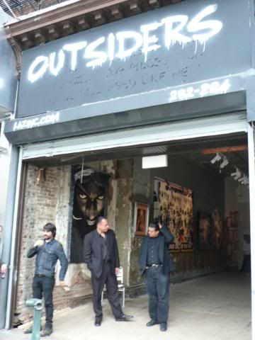
---------------

The folks at Glowlab did a project for the The New Museum's "Counter Culture" show (before it's Bowery building was built). "Brooklyn artists Dave Mandl and Christina Ray (oneblockradius.org) are currently creating a psychogeographic portrait of a single Bowery block."  Unfortunately the web site does not work, but Rhizome.org gives a bit of a description here.
  • Counter Culture ran from 7/10/04 - 8/14/04 and explored "the commerce and cultural diversity of the neighborhoods surrounding the Bowery-the future home of the New Museum-by pairing each of the six artists with a small business or organization in the area."    
  • One of the projects from this show, "From Darkness to Daylight" by Ricardo Miranda Zuniga, is still available online here.  Originally an installation piece at the now defunct SILO Gallery, this online element archives the video and audio content, as well as a host of links and other information. Worth checking out.
-----------------

The above mentioned projects are all new news to me, though there are a few I remember running across previously.   There is a piece on the Triple Canopy online site from a few years ago called Virtual Bowery by Dan Torop, which turned into a project called Bowery Birds.  Reading though it now I find it more interesting in than the first time, I suppose because I to am trying to decipher the meaning of the Bowery, personally and on a public scale.  A quote from the text: "I had thought of the street as one of the secret roots of the city, a place truer than the grid of streets and avenues it sunders."
  • The text also mentions a virtual recreation of the Lower East Side sponsored by MTV called "VLES.com", and I found a New York Times article about the project here, from 2008.  I tried to find it online, but it seems to no longer be archived.  It even has a Facebook page, but none of the links to the site work.  I imagine it was hard to keep up with all of the neighborhood and technological changes all happening so quickly over the last few years. 
----------------

If we go back in time, Martha Rosler's "The Bowery in two inadequate descriptive systems (1974-75)" is pretty much the definitive portrait of the Bowery in a pre-Luc Sante "Low Life" world.  

-----------------

Also, Hans Haacke's "Shapolsky et al. Manhattan Real Estate Holdings, A Real Time Social System, as of May 1, 1971 exposed the questionable transactions of Harry Shapolsky's real-estate business between 1951 and 1971. The work itself include detailed and accurate photo and text documentation of these transactions and landmarks. This solo show at the Solomon R. Guggenheim Museum, which was to include this work and which made an issue of the business and personal connections of the museum's trustees, was canceled on the grounds of artistic impropriety by the museum's director six weeks before the opening." (source: Wikipedia)

-----------------

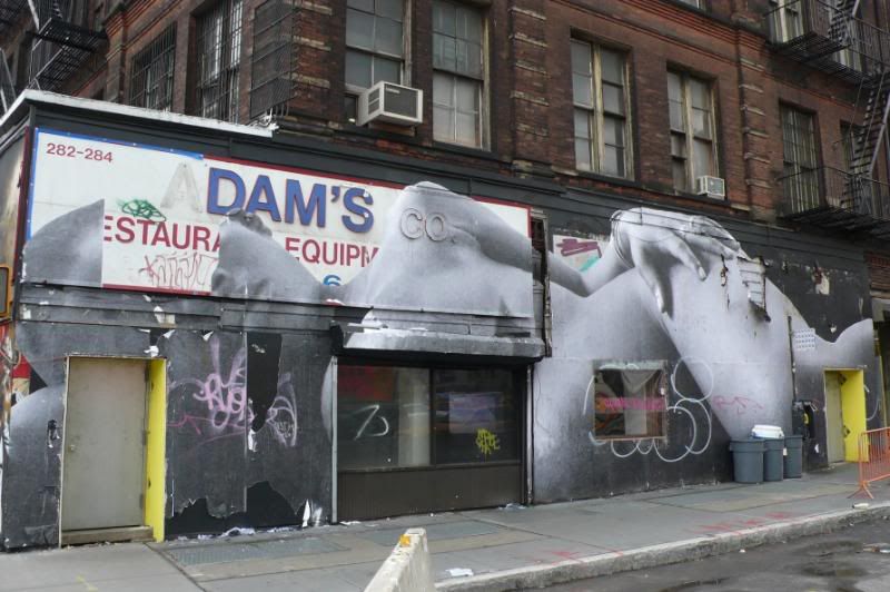
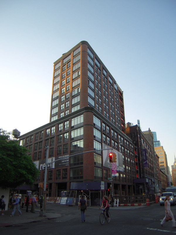
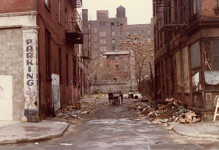
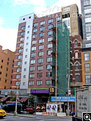
What is interesting is that while these projects have created a portrait of the neighborhood at a specific time, many seemingly have vanished.  Little is left but some references in articles, much like the buildings that once stood where Avalon Bowery Place is today.  We have physical proof of their existence through archived photos and articles, but these projects may be gone forever with little traces left.  As opposed to Rosler and Haacke's work, which is composed of hard copy images, the the ephemeral quality of web based projects makes me wonder what we'll be left with in the future.

Wednesday, December 15, 2010

Some shots from around East 1st Street circa early 2000's

EV Grieve recently posted a blurb about my post from a while back tracing property lines on the block where La Mama lives. (Thanks!)  Also Grieve let me know that Vanishing New York recently wrote up a great piece titled "Loss of Mars Bar" which chronicled the change this block has gone through over the years. (Thanks!)

I'm posting some images shot probably around 2001-3 from the block....these are all just screen captures culled from contact sheet scans, nothing fancy.  I have others lurking around somewhere.  I was starting a project around that time about the neighborhood and trying to figure out what kind of camera(s) to use, so they're mostly random shots of spaces which resonated with me for one reason or another (the empty lot on 1st St. and 2nd Ave, the UHaul lot, Liz Christy Garden, etc), not formal studies of anything.

More images to come in the future, but for now here's a few that I found:

Looking into the (emptied) UHaul lot, 1st st. and Bowery, SW corner


Same lot looking south when demo of the buildings started.

Looking north from Bowery and Houston.  Note - what will become the Bowery Hotel is still yellow here.  More on that building sometime soon.
The Liz Christy Garden in all its former glory, and the old school I mentioned in the previous post.
More Liz Christy Garden with the old fence still in place.

Crappy digital camera photo circa 2006 of what was built on the site.  Looking south from the west side of the Bowery.


Lot on NW corner of 1st st. and 2nd ave.


Same lot as above, looks to be later in time.


Tuesday, December 14, 2010

2007 - LIz Christy Garden reopens / 2005 - 295 Bowery Demolished

In 2005, most of the block between 1st and Houston Street, Bowery and 2nd Ave, was demolished for the second phase of the Avalon Bay buildings. Liz Christy Garden, the oldest community garden in the neighborhood, was threatened, but luckily was saved.

2007 Downtown Express article 


I agree with this quote:

"To (Brandon) Krall, the loss of the fence is especially upsetting. What was once a combination of wooden posts, iron rails and a rose-covered trellis is now a standard-issue, Parks Department fence. “It is part of the homogenization that is taking place all over the city,” she said. “They took our unique fence and replaced it with a generic (Parks Dept.) one.”"

It's still a beautiful and amazing space, but the new fence took away some of its individuality.

---------------

Many other buildings on the block,  like 295 Bowery (pictured below), weren't so lucky.  Along with a few other buildings, there was an old school that was to occupied by squatters (some took care of the park I think).  A chapel was attached to the school....originally it was going to be saved but only now did I realize that it wasn't.  The building's occupants had a sort of film festival one night in the chapel back in, probably, 1994?  I remember going with some friends and showing a film....the generator supplying the electricity was almost out of gas, so the film ran much slower than the soundtrack (on cassette).  It was kind of amazing.  And, well, the space was amazing, all broken down and rotting.  Entry was though the gym of the school (the floors were shiny and the ceiling high), which faced onto a sort of parking lot space looking toward 1st street.  It was so dark in the building, I can't imagine how anyone could find their way around. 

Another memory is the U-Haul that used to be on the corner.  It was just a trailer and a parking lot full of trucks, but very convenient.  I was freelancing, I think around '99, working for an artist and moving his studio from Tribeca + DUMBO to Chelsea/East Williamsburg.  I could pick up a truck in the morning, move a bunch of stuff, then drop it off at night, then stumble home exhausted.  This was also handy for those "helping a friend move" moves, since right around this time it seemed everyone was moving to Brooklyn (which then consisted of Williamsburg.  Maybe Greenpoint.  But not Bushwick or Sunset Park.)

I have some photos before the demo of the block, somewhere.  4x5 and 6x7 actually.  Time to dig them out. (next morning....found some - will post in the next few days!)

More 295 Bowery info here at the Lower East Side History Project, and The NY Times

photo: vanishing downtown

Saturday, December 11, 2010

1991 - The Cooper Square Plan; also RIP Mars Bar

This NY Times article from 1991 gives quite a bit of background on the political reasons why the lot on Houston and Bowery sat vacant for so long.  At this point, the lots are called "Site 1A" and "Site 2" (now where the Avalon Bay complexes are).

Also, read at The Gothamist about whats going to happen to the last few remaining buildings left on the "Site 2" block (btwn Houston and 1st st., Bowery and 2nd ave).  RIP Mars Bar and the locksmith that will copy ANY key.

Wednesday, December 8, 2010

Endangered Bowery Relic Up for Sale for $6.5 Million

Building from 1818!  Resembles the ones being torn down in my previous post. Amazing its still standing, really!

ny.curbed.com
streeteasy.com/

Tuesday, December 7, 2010

1934 + 1938 - Extra Place

Photos from the NYPL Digital Gallery 1934 + 1938.  Learn more about Extra Place from a post from I pit up a few days ago....

If you zoom into the 1938 photo you can see workers dismantling some early-mid 1800's housing that used to line 2nd street (see the post with the comparison of maps from different time periods for a refresher)

The La Mama building is on the left, and looks much the same as it does today (now that the usual wheat-pasting and graffiti items have been removed).


1864 - The Bowery looking south from Cooper Union

I know I said this blog was about the "New" Bowery, but I couldn't resist posting this 1864 painting of the Bowery looking south from what would have been a very new Cooper Union.

More info at the NYPL Digital Gallery


also same view: Cooper Sq. 1905

Sunday, December 5, 2010

1991 - Way Cleared for Long-Delayed Housing

NY Times article - rumblings from the early 90's during Mayor Dinkins reign about "several sites near the Bowery and Houston Street" (what is now the Avalon Bay complex of buildings).

"IN Cooper Square, after 31 years of a neighborhood battle against urban renewal plans that would have displaced 1,200 families, agreement was announced in December for several sites near the Bowery and Houston Street in Manhattan.

Plans call for building 560 new apartments for $16 million and renovating 430 in 37 buildings for $17 million. The renovated units will be for low- and moderate-income tenants. Of the new apartments, 200 will be rentals and 360 will be owner-occupied cooperatives or condominiums, with a fifth reserved for low-income residents and the rest for residents of middle and moderate income.

The Cooper Square Community Development Committee and Businessmen's Association helped negotiate the agreement, and local residents will help oversee the project and select tenants and owners. The project will include a community center."

from NYCityMap- 1996 map of Houston-2nd street off the Bowery - white squares are where the buildings eventually were built in the early 2000's

2008 - "Giant Girl Reclines on Houston Street"

NY Times article about "The Outsiders" show put on by Lazarides, a London gallery, and located in a gutted former restaurant supply store right on Houston and Bowery (now a fancy restaurant).  Artist JR pasted the figure of a reclining woman onto the outside of the building, which we learned"According to the artist, the current image is of a pregnant 16-year-old girl about to give birth in the streets of Monrovia, Liberia, and it is part of a series that focuses on violence to women in war-torn Africa."

I remember the show was supposed to "shake things up" but to me it felt a bit weird,  limiting, as the work had to fit all in one space.  The more traditional work fit with the space, like Conor Harrignton's paintings, but I suppose nonetheless an interesting experiment.


  (Photo: Ian Cox/Lazarides Gallery)

Thursday, December 2, 2010

Some "Extra Place" history

The alley next to La Mama is called Extra Place. It was hardly recognizable as an alley until recently, when part of the Avalon Bay conglomerate of buildings went up next door. Its been re-branded and architecturally rendered as a pedestrian mall, though only bits and bobs have come to fruition. Check out this piece for the Huffington Post about Extra Place by Kevin Walsh, the creator of Forgotten New York.  Thanks to Bowery Boogie for posting this picture from the Forgotten NY website, its made me do a bit of digging.

Extra Place in 1978. Photo: Bob Mulero, found at the Forgotten NY website.

Saturday, November 27, 2010

traces of farm property lines - still visible!

I've been researching the footprint the buildings on the block where La Mama Galleria is located, because some of them seem rather odd.

In a earlier post I illustrated the progression of the intersection at Bowery and Houston using aerial photographs from 1924, 1996, and 2008 from the nyc.gov interactive maps site.  La Mama is on the north side of 1st Street, Near the Bowery.  Looking at it from above, I noticed some of the buildings nearby were built at a weird angle.  Not just on that block, but the pattern seemed to extend across Second Avenue.

I did some digging though the NYPL digital archives, and learned that the weird angle actually relates to old farm property lines.  I'm not entirely sure why the buildings from 1867 seem to follow the lines so closely, my guess is that the grid was still relatively new and the plots of land were being sold in parcels to individuals by the farm owners.  I find the fact that even new buildings follow this footprint fascinating.

Click, then click again to enlarge:

Turning Cars Into Plowshares - 1999

Chelsea Garden Center briefly moves to the East Village on 2nd and The Bowery, next to the Amato Opera (R.I.P.):

Turning Cars Into Plowshares

Origins of the Avalon Bay Empire on the Bowery......

I have hazy memories of seeing some sort of rendering of the ginormous housing developments which now span Houston St - 2nd St.  It was around 2000, and in some sort of document I stumbled across in the the Cooper Union library.  According to this article, a plan had been in the work for decades, so the information I found could have been much older than what was being proposed at the time (which got built).

Memorable quotes from the NY Times article "At Cooper Square, a New Player Takes the Stage":

"TWENTY years ago -- or 30 or 40 for that matter -- the Cooper Square Committee would have scorned the redevelopment plan for three acres of urban renewal land off East Houston Street that a community task force worked out with the Giuliani administration a year ago. The committee is a nonprofit community development organization that formed four decades ago to resist the redevelopment plans of Robert Moses in the neighborhood."

---------The "suburbanization" of New York maybe can begin to be explained by things like this that started happening under Giuliani--------

"AvalonBay Communities, based in Alexandria, Va., is undertaking the Cooper Square project in partnership with Williams Jackson Ewing, a national retail developer based in Baltimore, and Blackacre Capital, a private investment firm in New York City. Phipps Houses, the New York-based nonprofit housing company, will participate as the developer and owner of a portion of the low-income apartments."


"It is unusual for a national real estate company to undertake residential development in New York City, and even more unusual for it to take the path of bidding for a city-sponsored proposal. For most such companies, the major capital investment required at the beginning of a process of uncertain duration and outcome seems daunting. Companies experienced in the vagaries of New York City development are normally the only participants."

"But the attraction is the chance to own new rental property in a market that is unlikely to become oversupplied with it. ''Our strategy is to focus on the strongest markets,'' said Bryce Blair, president of AvalonBay. ''The markets with the strongest constraints on supply over the long term will be the healthiest.''"

"The design and architectural plan is the work of the New York office of Arquitectonica, an international firm that was founded in Florida in 1977 and became known in its early days for a flamboyant condominium in Miami called the Atlantis, in which a 37-square-foot cube was cut to create a 10-story interior skycourt. Bernardo Fort-Brescia, a founder of the firm, is the chief architect for Cooper Square."

Wednesday, November 24, 2010

History of Dixon Place

NY Times article from 2004 - great to know the history of Dixon Place and the work that went into making it run!

Tuesday, November 23, 2010

Bowery Bar Beginnings - 1994

NY Times article from '94........more about this to come. 


"The NoHo Neighborhood Association and some members of Community Board 2 argue that the bar, and others they believe would open in its wake, will erode the character of the area by changing it from a haven for light industry and artists into a trendy night spot."

Pre-1994 this space was used as a parking lot for Cooper Union, and a work/storage space for its Engineering school.  I have some B&W pictures kicking around of the interior from my college days, I will post some when I find them.  I don't think I have any of the exterior, but I'm not 100% sure.

Image via DNA info

"Apartment Building to Rise on Infamous Bowery" circa 2000

Here is a NY Times article about 199 Bowery, near Spring st, oddly called NoLiTa Place, yet described as being in the Lower East Side.  Anyone remember this building going up?

It seemed kinda ludicrous at the time, being so upscale.  Crash Mansion is in the basement, and I remember The Pioneer Bar opening across the street.  We went there after an opening in Soho in the early 2000's...it felt so weirdly out of place being so grandiose and upscale.

"In the heart of the Bowery, a name synonymous with what the Encyclopedia of New York City describes as a onetime ''place of squalor, alcoholism and wretchedness'' that even in the mid-1990's ''seemed likely to remain the sanctuary for the forgotten in American society,'' a spanking new $30 million apartment building is about to go up, complete with retail shops, a fitness room, rooftop terrace and 24-hour doormen."

"''Most of the stores in the Bowery that supply chairs, lights, stoves and the like to restaurants and other businesses were on 20- to 30-year leases. And when the leases expired, the spaces became available for people whose tastes appeal to the market in SoHo or the Village, but who can't afford the rents there.''"

1983 - St. Marks Place

NY Times Article "THE SHAPE OF ITS FUTURE SPLITS EAST VILLAGE", talking about new commercial revitalization and commercial revitalization in the East Village.

This is the first wave of gentrification, before the recession of the early 90's, but also interesting to note.

''Everybody's saying that more middle-class people are moving into the area,'' she said. ''The impression is that new money is coming in. I'm sure the rents are going up.'' 

"Since 1969, when Mayor John V. Lindsay's administration sought unsuccessfully to rezone part of Third Avenue for high-rise luxury apartment buildings, three attempts to change zoning in the East Village have been blocked. These were proposals to gain variances for what are now three parking lots on the east side of Third Avenue between Ninth and 12th Streets, and build high-rise apartments of higher density than the surrounding housing; the most recent of these attempts failed last year. According to Ray Spillenger, treasurer of the Third Avenue Tenants, Artists and Businessmen's Association, the proposals were voted down because ''any upzoning would doom the rest of the area and low-rise property values would zoom.''"

''The 'East Village' is an invention of the real-estate people who want to make it trendy, a chic part of town where young singles can make the scene,''

Sunday, November 21, 2010

"The Bowery: Manhattan's Hottest Property." 2004

Via Curbed, a press release by Newmark New Spectrum introducing the New Bowery:

" Where have all of the pawn shops, brothels and flop houses gone? The Bowery Manhattan's Hottest Property
The Bowery, the neighborhood formerly known as an undesirable melting pot of homeless street dwellers, and low-end retail establishments is getting a major face-lift. New real estate developments in the area are giving it a completely different vibe and turning it into one of the most up-and-coming areas in the city.
A Chrystie Place is a brilliant example of the significant change. Bordering Christy Street, E. Houston & Bowery, A Christy Place is a mixed income residential and retail complex developed by Avalon Bay, William Jackson Ewing & Phipps Houses that will house an 88,000 square foot Whole Foods as well as a community swimming pool and gym. The New Museum, whose design will incorporate Japanese architecture, will be housed on Bowery as well; and The Surface Hotel, just east of the Bowery on Rivington Street with its modern glass structure, is in the midst of construction.
Although the face of the area is changing, some of the former flavor is still intact, with popular establishments like Katz's deli, Russ & Daughters, Economy Candy and Yonah Shimmel, maintaining their hold on the community. The Bowery is becoming one of those perfect New York neighborhoods, one that combines a dash of new luxury, with the essence of the old.
The emergence of the neighborhoods surrounding the Bowery is another example of how Lower Manhattan, south of 14th street, continues to grow and develop to meet the growing needs of a new generation of prosperous people who love the downtown Lifestyle. notes Benjamin Fox of Newmark New Spectrum, the Country's leading retail real estate firm."

1997 - The New Bohemia: It's East of Soho and Still Unspoiled

"The New Bohemia: It's East of Soho and Still Unspoiled" by John Pareles

This article isn't Bowery-centric, but I think its notable in terms of how the view of things happening below East Houston (or even the amount of things), shifted in the late 90's.

Interesting details:

"For the current Ludlow Street scene, it was a mid-1990's police crackdown curtailing major drug sales that let the neighborhood kick into high gear." (maybe that explains why, when I came back from graduate school in 1997, things seemed to have changed radically even though I was only gone for a year.)

Hence:

"It's not entirely sanitized; visitors might glimpse drug transactions on Stanton Street or Rivington Street. But the area is in the promising part of a pattern that's familiar from SoHo and the East Village: the transition from rundown neighborhood to artists' hangout to hip destination to overload." (I think we've hit overload++)

Looks like this started all the way back in 1996:

"Bars, clubs and small performance spaces have proliferated during the 1990's, so much so that last year, Community Board 3 called for a moratorium on new liquor licenses along Ludlow Street. But activity has hardly tapered off."

And geez, does anyone remember that cabaret law Giuliani pulled out of his pocket? "In line with the city's enforcement of the cabaret laws, places like Bob have signs posted that say, ''No dancing by order of the Department of Consumer Affairs.'' "


Also, I think its worth noting that in nearly every one of these articles I've posted so far, Starbucks has been mentioned in a negative way as a gentrifying force (this is pre Duane Reade and Banks)

Friday, November 19, 2010

Bowery btwn 5th + 6th streets circa 2004

"Coming soon" site of the Cooper Square Hotel, 2004, often called "Dubai on the Bowery".


Same site circa 2007

"Oh, It's Not What It Used to Be" - Bowery circa 2000

NY Times article circa 2000 about the Bowery, written by someone who spent a lot of time there as a child in the 60's probably.

Notes:

"Today on the Bowery the tallest building -- other than the 1970's Confucius Plaza in Chatham Square -- is the 10-story Salvation Army Chinatown Corps, No. 225, near Rivington Street; most are three or four stories."

"Still seedy around the edges, the Bowery is not yet gentrified -- there's no Starbucks, no Gap -- and it's not clear whether it will soon look more like SoHo, to the west."

"Old-timers gape at a two-story terraced gray penthouse, recently erected atop a dark orange brick building." ---- (While there are other seemingly older penthouse structures visible, I think this one is the first real sign of the beginning of what the Bowery has become.)

Also, another mention of its unique street arrangement:

"The Bowery interrupts the city's straightforward grid. Streets like Prince, Spring and Bleecker on the west side, and Stanton, Rivington and First on the east, end -- or begin -- at the Bowery. In some cases, the names change: Delancey becomes Kenmare; Bond becomes East Second; Great Jones becomes East Third."

Wednesday, November 17, 2010

EV Transitions: A.T. Stewart, John Wanamaker, the Great Fire, and the Great Flood (Part II)


The "new" Wanamaker building is where K-Mart is on Astor Place......one of my favorite buildings in NY, so well proportioned (1903 - Burnham).  This shows a film of the old building burning down.  Fascinating.

"This is where streets go to die" - Bowery circa 2003


This NY Times article titled "Palimpsest Street" from 2003 gives you a mini rundown of the the Bowery's history, and details some sensibility of its different manifestations.  Originally the article probably had pictures (I wish it still did). 

During this time period there was no way of knowing that the Bowery was on the precipice of massive change, just that things were generally shifting in a more upscale direction.  No one knew if it was sustainable at this point.

I like the author's hypothesis as to why the Bowery had essentially sat unchanged for so many decades:

"One answer is surely physical. Like most of New York, the Bowery is much cleaner than it used to be, but it is still an ungainly street, singularly devoid of shade. An informal survey counted only 19 trees, many of them little more than saplings. And in its northern reaches, particularly, the Bowery is almost as broad and as busy as a highway. Trucks rumble constantly up and down its six lanes, either serving the avenue's many wholesalers or on their way somewhere else. And if geography is destiny, then the Bowery will never change. This is where streets go to die. Prince and Spring Streets from the west; Rivington, Stanton and First Streets from the east. All come to dead ends here, creating the impression that the Bowery is somehow cosmically misaligned -- an ineluctable border area, permanently detached from any of the neighborhoods surrounding it.

Or perhaps there's a simpler reason that the Bowery has remained the Bowery. Modern cities developed for the most practical of reasons, as marketplaces of goods, services and ideas. It is only when the markets leave that cities and neighborhoods begin casting around existentially for reasons to exist. On the Bowery, neither the industrial markets nor the artists ever left. The street remained more or less content unto itself. In a way, the Bowery is the only part of the ''real'' city left in Manhattan."


You can check out some aerial photos taken from different time periods by using the NYC.gov interactive map feature (super cool).

Bowery and Houston circa 1924

Bowery and Houston circa 1996


Bowery and Houston circa 2008


Dive bars in NY circa 1996

I'm working on a big piece for a show I'm doing at La Mama Gallery in January (also showing Wil Ortega's work).  La Mama is located right off the Bowery, on 1st street, near the Liz Christy garden.  Also, I suppose I should mention its also nowadays sandwiched between one of the largest (luxury) housing developments built in recent times in the neighborhood, built by Avalon Bay, who previous to this complex on the Bowery had mostly build suburban apartment complexes in places like New Jersey. Anyway, if I can pull it off, my portion of the show will incorporate some of the last 20 years of history in terms of the Bowery - pretty much the time person when I would have traversed it as a Cooper Union student, then staff and faculty, and a general NYC downtown resident.

I have a lot of memories, but they tend to be a bit fuzzy.  Images are in my heads, but dates are uncertain.  I've started doing some research, mostly using the NY Times archive, which so far has been very helpful.  I typed in Bowery and Houston and a bunch of stuff popped up.  I was tryign to determine when the aforementioned housing development was proposed, because i remember seeing a rendering in a book in the Cooper Library circa 1999?  2000? and thinking "well, thats never going to happen".  And it didn't, at least as far as I can tell. Originally it was proposed as city housing.  Then it was sold to a private developer.  So, big difference there in terms of what it represents.  Still looking into finding that rendering. 

Anyway, from time to time I'm going to post some of the articles/images I find, and my thoughts here.  

Note the date.  This one is from 1996:


enjoy.