Showing posts with label LES. Show all posts

Tuesday, December 14, 2010

2007 - LIz Christy Garden reopens / 2005 - 295 Bowery Demolished

In 2005, most of the block between 1st and Houston Street, Bowery and 2nd Ave, was demolished for the second phase of the Avalon Bay buildings. Liz Christy Garden, the oldest community garden in the neighborhood, was threatened, but luckily was saved.

2007 Downtown Express article 


I agree with this quote:

"To (Brandon) Krall, the loss of the fence is especially upsetting. What was once a combination of wooden posts, iron rails and a rose-covered trellis is now a standard-issue, Parks Department fence. “It is part of the homogenization that is taking place all over the city,” she said. “They took our unique fence and replaced it with a generic (Parks Dept.) one.”"

It's still a beautiful and amazing space, but the new fence took away some of its individuality.

---------------

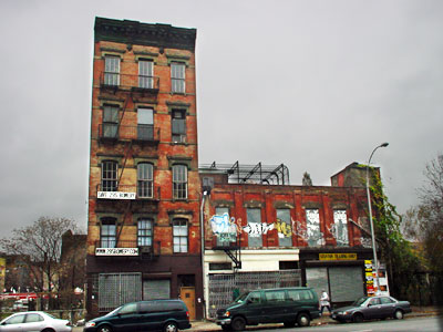
Many other buildings on the block,  like 295 Bowery (pictured below), weren't so lucky.  Along with a few other buildings, there was an old school that was to occupied by squatters (some took care of the park I think).  A chapel was attached to the school....originally it was going to be saved but only now did I realize that it wasn't.  The building's occupants had a sort of film festival one night in the chapel back in, probably, 1994?  I remember going with some friends and showing a film....the generator supplying the electricity was almost out of gas, so the film ran much slower than the soundtrack (on cassette).  It was kind of amazing.  And, well, the space was amazing, all broken down and rotting.  Entry was though the gym of the school (the floors were shiny and the ceiling high), which faced onto a sort of parking lot space looking toward 1st street.  It was so dark in the building, I can't imagine how anyone could find their way around. 

Another memory is the U-Haul that used to be on the corner.  It was just a trailer and a parking lot full of trucks, but very convenient.  I was freelancing, I think around '99, working for an artist and moving his studio from Tribeca + DUMBO to Chelsea/East Williamsburg.  I could pick up a truck in the morning, move a bunch of stuff, then drop it off at night, then stumble home exhausted.  This was also handy for those "helping a friend move" moves, since right around this time it seemed everyone was moving to Brooklyn (which then consisted of Williamsburg.  Maybe Greenpoint.  But not Bushwick or Sunset Park.)

I have some photos before the demo of the block, somewhere.  4x5 and 6x7 actually.  Time to dig them out. (next morning....found some - will post in the next few days!)

More 295 Bowery info here at the Lower East Side History Project, and The NY Times

photo: vanishing downtown

Sunday, November 21, 2010

1997 - The New Bohemia: It's East of Soho and Still Unspoiled

"The New Bohemia: It's East of Soho and Still Unspoiled" by John Pareles

This article isn't Bowery-centric, but I think its notable in terms of how the view of things happening below East Houston (or even the amount of things), shifted in the late 90's.

Interesting details:

"For the current Ludlow Street scene, it was a mid-1990's police crackdown curtailing major drug sales that let the neighborhood kick into high gear." (maybe that explains why, when I came back from graduate school in 1997, things seemed to have changed radically even though I was only gone for a year.)

Hence:

"It's not entirely sanitized; visitors might glimpse drug transactions on Stanton Street or Rivington Street. But the area is in the promising part of a pattern that's familiar from SoHo and the East Village: the transition from rundown neighborhood to artists' hangout to hip destination to overload." (I think we've hit overload++)

Looks like this started all the way back in 1996:

"Bars, clubs and small performance spaces have proliferated during the 1990's, so much so that last year, Community Board 3 called for a moratorium on new liquor licenses along Ludlow Street. But activity has hardly tapered off."

And geez, does anyone remember that cabaret law Giuliani pulled out of his pocket? "In line with the city's enforcement of the cabaret laws, places like Bob have signs posted that say, ''No dancing by order of the Department of Consumer Affairs.'' "


Also, I think its worth noting that in nearly every one of these articles I've posted so far, Starbucks has been mentioned in a negative way as a gentrifying force (this is pre Duane Reade and Banks)

Friday, November 19, 2010

"Oh, It's Not What It Used to Be" - Bowery circa 2000

NY Times article circa 2000 about the Bowery, written by someone who spent a lot of time there as a child in the 60's probably.

Notes:

"Today on the Bowery the tallest building -- other than the 1970's Confucius Plaza in Chatham Square -- is the 10-story Salvation Army Chinatown Corps, No. 225, near Rivington Street; most are three or four stories."

"Still seedy around the edges, the Bowery is not yet gentrified -- there's no Starbucks, no Gap -- and it's not clear whether it will soon look more like SoHo, to the west."

"Old-timers gape at a two-story terraced gray penthouse, recently erected atop a dark orange brick building." ---- (While there are other seemingly older penthouse structures visible, I think this one is the first real sign of the beginning of what the Bowery has become.)

Also, another mention of its unique street arrangement:

"The Bowery interrupts the city's straightforward grid. Streets like Prince, Spring and Bleecker on the west side, and Stanton, Rivington and First on the east, end -- or begin -- at the Bowery. In some cases, the names change: Delancey becomes Kenmare; Bond becomes East Second; Great Jones becomes East Third."

Wednesday, November 17, 2010

"This is where streets go to die" - Bowery circa 2003


This NY Times article titled "Palimpsest Street" from 2003 gives you a mini rundown of the the Bowery's history, and details some sensibility of its different manifestations.  Originally the article probably had pictures (I wish it still did). 

During this time period there was no way of knowing that the Bowery was on the precipice of massive change, just that things were generally shifting in a more upscale direction.  No one knew if it was sustainable at this point.

I like the author's hypothesis as to why the Bowery had essentially sat unchanged for so many decades:

"One answer is surely physical. Like most of New York, the Bowery is much cleaner than it used to be, but it is still an ungainly street, singularly devoid of shade. An informal survey counted only 19 trees, many of them little more than saplings. And in its northern reaches, particularly, the Bowery is almost as broad and as busy as a highway. Trucks rumble constantly up and down its six lanes, either serving the avenue's many wholesalers or on their way somewhere else. And if geography is destiny, then the Bowery will never change. This is where streets go to die. Prince and Spring Streets from the west; Rivington, Stanton and First Streets from the east. All come to dead ends here, creating the impression that the Bowery is somehow cosmically misaligned -- an ineluctable border area, permanently detached from any of the neighborhoods surrounding it.

Or perhaps there's a simpler reason that the Bowery has remained the Bowery. Modern cities developed for the most practical of reasons, as marketplaces of goods, services and ideas. It is only when the markets leave that cities and neighborhoods begin casting around existentially for reasons to exist. On the Bowery, neither the industrial markets nor the artists ever left. The street remained more or less content unto itself. In a way, the Bowery is the only part of the ''real'' city left in Manhattan."


You can check out some aerial photos taken from different time periods by using the NYC.gov interactive map feature (super cool).

Bowery and Houston circa 1924

Bowery and Houston circa 1996


Bowery and Houston circa 2008


Dive bars in NY circa 1996

I'm working on a big piece for a show I'm doing at La Mama Gallery in January (also showing Wil Ortega's work).  La Mama is located right off the Bowery, on 1st street, near the Liz Christy garden.  Also, I suppose I should mention its also nowadays sandwiched between one of the largest (luxury) housing developments built in recent times in the neighborhood, built by Avalon Bay, who previous to this complex on the Bowery had mostly build suburban apartment complexes in places like New Jersey. Anyway, if I can pull it off, my portion of the show will incorporate some of the last 20 years of history in terms of the Bowery - pretty much the time person when I would have traversed it as a Cooper Union student, then staff and faculty, and a general NYC downtown resident.

I have a lot of memories, but they tend to be a bit fuzzy.  Images are in my heads, but dates are uncertain.  I've started doing some research, mostly using the NY Times archive, which so far has been very helpful.  I typed in Bowery and Houston and a bunch of stuff popped up.  I was tryign to determine when the aforementioned housing development was proposed, because i remember seeing a rendering in a book in the Cooper Library circa 1999?  2000? and thinking "well, thats never going to happen".  And it didn't, at least as far as I can tell. Originally it was proposed as city housing.  Then it was sold to a private developer.  So, big difference there in terms of what it represents.  Still looking into finding that rendering. 

Anyway, from time to time I'm going to post some of the articles/images I find, and my thoughts here.  

Note the date.  This one is from 1996:


enjoy.